Why do you need a level
Content
A level is one of the most common geodetic instruments designed to estimate the difference between two, three or more heights relative to some constant. Today, without it, none of the work is carried out when marking terrain, erecting power lines, calculating the construction of roads, buildings, and so on. These devices are widely used for all kinds of repair work, such as:
- Pouring floors;
- Construction of foundations;
- Plastering walls (installation of beacons);
- Installation of stairs;
- Wallpapering;
- Laying tiles and others.
What is a level for?
As mentioned above, various types of levels are widely used both in geodetic work and in construction. Working with laser and digital levels is simple, so even an untrained person can handle it without difficulty.
So what is a level for? Using a level, most often:
- They mark the construction site for the foundation of the future structure;
- Mark sidewalks, playgrounds and garden paths;
- Lay out the park, garden, fences, etc.;
- Carry out land management work.
When finishing and performing repairs, the level is used to:
- Mark the places for laying all kinds of communications;
- Install doors and windows evenly;
- Mark ceilings and baseboards;
- Monitor the evenness of the installation of floors, installation of internal partitions and much more.
This is not a complete list of those works where an optical level is used. Without a doubt, this measuring tool is very convenient to use and is of great importance when performing almost any construction work.
Source: samastroyka.ru
Residual
— The difference between the resulting value and what should be.
Normal
— Perpendicular to the surface of a given point.
Leveling the route
— A type of geodetic work aimed at determining the marks of points fixed on the axis of the route.
Lowland
— A type of plain lying at an altitude of 0 to 200 m above or below the level of the World Ocean.
Nadir
— The point of intersection of the celestial sphere with a plumb line extended down from the observation point. Nadir is opposite to zenith.
Zero depths
— Conditional surface from which depth marks are given on marine navigation charts. The established zero depth in the Russian Federation for seas without tides (Baltic, etc.) and lakes is the average long-term level; in tidal seas (Okhotsk, etc.) - the lowest sea level, derived from level observations.
Normal planes and sections
- All planes passing through the normal are called normal planes, and their section of the ellipsoid surface is called a normal section.
Leveling
— Determination of elevations between points on the earth’s surface, and then the heights of points relative to some selected point or above sea level. There are geometric, trigonometric and other types.
Leveling network
— A system of points on the earth’s surface, the heights of which above sea level are determined by leveling and fixed on the ground by benchmarks.
Nomenclature of topographic maps and plans
— A system for marking and marking individual sheets of a multi-sheet map.
Navigation satellite receiver
— A device consisting of an antenna, a radio receiver and a computer (processor), designed to receive and process navigation signals in order to obtain the information necessary for the consumer (spatio-temporal coordinates, direction and speed).
Celestial sphere
— An imaginary surface of an arbitrary radius with a center at an arbitrary point onto which the celestial bodies are projected.
Navigation satellite
— A satellite that emits a radio signal containing navigation information, the reception of which is necessary to determine the location of the consumer's receiver.
Source: Tochno-Rostov.ru
Where it all began
History today has documentary evidence that humanity knew and used levels back in the second century BC. These were communicating vessels connected by a transparent flexible element.
At the beginning of the 17th century, Galileo Galilei invented the first telescope. A few decades later, rangefinder threads appeared on the glasses of these devices. Only in 1890 did builders receive a truly complete and sufficiently accurate device. It is gratifying that Russian scientists also made their contribution to this invention.
Research into modernization and improvement of performance characteristics continues today. Individual laboratories and entire institutes in Germany and Russia, China and the USA. Japan and Switzerland continue to contribute to the device's pursuit of perfection.
The design of an optical level and features of generations of devices
Today there are different leveling devices. They all have their advantages and disadvantages. When choosing, you need to take into account the cost, equipment, and service life. There are optical, digital and laser instruments. The most popular today is the optical level. There are also several types of them. The main difference is in the main parts: the telescope, the level, and the stand. Usually the level is attached together with the pipe, which in turn is located on a stand, which can be folding or, on the contrary, rigidly attached.
Leveling
This concept comes from the French “nivèlement” - alignment. This procedure is performed when it is necessary to determine the difference in heights of points in space. Here, both certain horizontal lines and constants such as, for example, the level of the world ocean can be taken as the “zero mark”.
Without leveling the terrain, not a single serious construction project, not a single large-scale architectural project, begins. Today there are a sufficient number of ways to determine the deviation of the terrain from a certain horizontal:
- Geometric - this method is based on the principles of operation of levels or slats (we will talk about this in more detail in this article);
- Trigonometric leveling is carried out using goniometric instruments (theodolites or tacheometers);
- Barometric - as you know, atmospheric pressure strongly depends on the altitude of objects. It is quite logical that barometers with this method are the main assistants;
- Hydrostatic - the method is based on the property of water to be in communicating vessels at the same level;
- Satellite - leveling is based on measuring the travel time of the reflected signal;
- Radar is a method, like the previous one, that detects a reaction to a radio signal obstacle.
For each type of leveling, humanity has provided specific devices. The process of modernizing them, improving measurement accuracy and ease of use continues to this day.
Purpose of the level
One of the most important geodetic works carried out during the construction of any objects is leveling.
For these purposes, an appropriate tool is used - a level.
The purpose of this operation is to determine the difference in heights of specific points on the ground, as well as to study landforms.
Levels are used for:
- design and creation of high-precision geodetic structures;
- installation of technical equipment and structures, for example, for installing power transmission poles;
- decorating the area, leveling large areas;
- predicting the amount of subsidence of any buildings;
- construction work indoors, for example, installation of floors and ceilings.
Level in geodesy
In everyday life, levels are often used when renovating premises.
For these purposes, there is a separate type of device, which is often called laser levels.
They project laser beams onto flat surfaces and are great for marking corners.
Among other things, the use of a laser level ensures the accuracy of laying tiles and any material where right angles and lines are required.
For this reason, the device is also used for wallpapering, where it is necessary to maintain strictly vertical joint lines.
The level will also be useful for an electrician.
With its help, you can clearly position the location of sockets, switches, safety panels at the same level from the floor, or relative to the horizon.
Electrician working with a level
Also in everyday life, the simplest hydrostatic levels are used, operating on the principle of two communicating vessels with liquid.
Level device
Optical ones are considered the simplest. These devices are a complex of devices (instruments) united by one purpose. So the bubble level is responsible for the horizontal position of the device itself. Rangefinder - responsible for the accuracy of measuring the distance to an object.
The most common type of rangefinder is a lens with lenses capable of repeatedly bringing (zooming in) the observed objects. A special rod acts as a standard and measurement adjuster.
Horizontal adjustment (adjustment) in these devices is carried out using support screws. Their number is three, which coincides with the number of points defining the plane.
Typically, this measurement method involves two to three people. Despite its simplicity, this method is still labor-intensive, time-consuming, and subject to errors, although it is quite accurate.
Speaking about simpler and smaller-scale measurements, we can mention elementary levels in the form of a hollow tube with transparent walls. Water placed inside acts as a sensor or a fairly accurate indicator to determine the height of one object relative to another. This device is still actively used in private construction and for various repair work.
Laser levels are considered to be a product of the age of cosmic speeds and electronics. Firstly, these are precision instruments. Help to minimize errors here:
- Tripod;
- Limb - a device for preliminary measurement of angles (high-precision instruments may not have it);
- Electronics.
Secondly, thanks to the ability to measure in several planes at once, laser levels allow you to indicate the vertical, horizontal and distance of objects in the widest range. And with excellent accuracy (measurement errors here amount to tenths of a millimeter).
For reference , the light beam used here can be either red (used mainly in enclosed spaces) or green - it is better visible in open areas.
Level - features of using the device
The purpose of the level is to determine the difference resulting from differences in the levels of placement of individual points in space, in relation to the surface adopted during measurement. Specialists in the field of geodesy and topography use the device to study the features of the relief, and the construction level is used by workers to comply with the specified parameters during construction and installation work, as well as when carrying out repairs of varying degrees of complexity.
In fact, this device allows you to level the surface in a horizontal or vertical plane and give the object a slope at a given degree.
In open areas you can:
- mark the area for the foundation;
- carry out a breakdown of the personal plot along the lines of planting vegetation;
- plan the arrangement of paths in the garden;
- carry out land management work.
In construction and repair work it becomes possible to:
- mark lines for placing communications;
- adjust the horizontal floor and vertical for the walls;
- assess the correct installation of skirting boards and ceilings;
- install windows and doors correctly;
- install built-in furniture.
Components of success
It will not be a discovery that the accuracy of measurements largely depends on the quality of the materials from which the device is made.
The most popular version of both the device and the tripod for it is aluminum. It is lightweight and durable at the same time. This non-ferrous metal significantly facilitates the design, which is important during transportation.
Only fiberglass can compete here, but it is preferred in the manufacture of small (up to 50-70 cm in height) tripods.
Classic wooden tripods are still on the market, although they are more expensive than their competitors.
Optical models of levels
Prism or optical levels are a structure consisting of two parts - a stand and a main block. Measurements using this tool are made manually:
- The position of the telescope is adjusted;
- The eyepiece is focused;
- The position of the level is leveled and fixed.
The measurement is taken after installing and setting up the instrument. This model can be used to study the area where the construction of a building or bridge is planned. The main condition is the participation of two people in the measuring process: one will hold the staff with the marked divisions, and the second will take measurements and record the result.
The optical device does not depend on batteries or other power sources; all manipulations can be performed during daylight hours in any weather. The main requirement is careful handling, since impacts or strong shaking can damage the device and lead to its imbalance.
Directly about the devices themselves
Optic
A professional level for determining differences in heights, inclination angles and distances of objects during the repair of old roads and the construction of new ones.
The horizontal position of the level itself is controlled using a bubble level. A stable position is ensured by an air compensator, magnetic damper or mechanical adjustment.
The main and additional scales of the device are located directly on the glass of the device. The final results are determined using special tables. More modern electronic levels can significantly facilitate the process of measurement and calculation.
Digital (aka electronic)
For reference Abroad, this type of level is labeled DigitalLevel. The operating principle is based on automatic barcode and barcode reading and digital data processing by the processor.
Laser level
Designed primarily for constructing points and planes. Its areas of application: for repair, reconstruction and modernization of indoor premises - the main ones, but not the only ones. Landscape planning, marking the site for future construction are also the areas of “responsibility” of these devices.
For reference, the essence of the process inside these devices is to convert a beam of light into a horizontal, vertical or inclined plane. This is what allows you to instantly obtain the horizon (vertical or slope) based on the assignment or fact of measurements.
At the same time, laser levels can perform several tasks at once. So, for example, placed in a room, it can show the horizontal on all walls at once, indicate the angle of inclination or the ideal plumb line.
Additional options here may be: electronic alignment of the “zero” horizontal, projection in volumetric “3D” format, memory for 10, 20 and 50 previously made measurements, control from a separate keyboard and others.
Laser levels can work with both red and green beams. The first is the most practical indoors and guarantees high accuracy in the range from 0 to 500 meters. More visible in the solar spectrum, the green beam is more often used in open areas, where distances of even 1 km are “subject to” it.
How to choose an optical level - determine the classes of the instrument
When deciding how to choose a level, you need to take into account the required measurement accuracy. And this will depend on the level of geodetic work being carried out. In our country, levels are divided into several classes. If the main high-altitude base is required, then these are classes 1 and 2 of devices. If it is necessary to perform work with the highest precision, class 1 devices are needed. High results can only be obtained with the most modern geodetic equipment. They allow you to use the appropriate measurement methods.
How to choose the optimal device
According to folk wisdom, a tool must be suitable for the task assigned to it. In other words, to help repair an apartment or house, it is enough to purchase a household laser level with a measurement range from 5 to 50 meters. This will be quite enough for high-quality assessment and marking, both in the premises itself and on the land outside it.
A prerequisite for all these devices is the presence of horizontal control. This could be a basic bubble level. Based on the most popular repair jobs, the optimal set of capabilities of household levels comes down to determining the horizontal and vertical. Devices with wider capabilities and more accurate measurements belong to the professional class and purchasing them is considered more than irrational.
Note: If you need inclined surfaces, you should look for a model with three or even four beams. Household appliances offer sweeps (adjustable angles) of up to 130 degrees, which is quite enough to help implement most design ideas.
It will not be superfluous to know about the power supply system of the purchased level. It is desirable that these be standard cells or a battery. There is no need for exclusive solutions here. A device that cannot be charged is of little use.
A useful option is the presence of a self-leveling system. It will eliminate errors during positioning and eliminate the need for labor-intensive and responsible setting of “zero”.
The following additional accessories will be very useful:
- Protective glasses;
- Tripod;
- Clothespin for fastening on vertical and inclined planes;
- Protective housing.
Safety glasses will not only protect the eyesight of those working with a laser level, but will also improve vision of the beam itself. A tripod is convenient in cases where the device needs to be placed at a certain height above the ground.
Clothespin - when working with inclined surfaces. An alternative can be a universal magnetic pad that can fix the level on any metal surface. The protective case will prevent damage to the device if it gets wet and will protect it if it accidentally falls.
Note: Most level manufacturers assign coefficients to device housings. They inform about the degree of safety from exposure not only to water, shock loads, but also dust, temperature, ultraviolet radiation and other factors.
If the device is purchased without a tripod, the size of the socket for mounting it will be valuable information for the future. Sooner or later, when the device is actively used, the need for a reliable mount will arise, which means that searching for a tripod with knowledge of the size of the mating device will be as effective as possible.
When choosing a level for your needs, we especially pay attention to such passport data as:
- Measurement accuracy
- Working beam length
- Number of emitters (number of measurement planes)
- Duration of continuous operation
A measurement accuracy for repair work equal to plus or minus 0.2 mm per meter is considered sufficient. The working beam length or maximum object distance of 40-50 meters is more than sufficient even for owners of spacious houses and apartments. The operating time of the device without recharging is an important value only if there is no power supply at the site. Almost every device has the ability to operate both from batteries and from the network.
A complete analysis of construction tools: what is a level?
In everyday life, a level is extremely rare. It makes no sense for an ordinary person to keep this (full-fledged) tool at home, because the frequency of its use in the household will tend to zero for 90%. All measuring work is carried out with improvised materials, more familiar to people since the times of the Soviet Union. Let's look in detail at what a level is and what parameters characterize the instrument in general.
1) What is a level + its characteristics
Let's remember one phenomenon from the life of an ordinary person - people with strange devices on tripods that measure something. From the outside it may seem that they are simply creating the appearance of work on site, but in fact the workers are engaged in one of the most important aspects of the initial stage of construction - determining the relief and height difference.
Where are levels used in practice:
- design of objects with high precision requirements;
- development of geodetic structures;
- design and installation of structural units (lines) of a technical direction. For example, these are power lines;
- decoration according to location;
- bringing large areas to the same level in height;
- a variable in calculations in soil subsidence, which is important when laying the foundation;
- construction work of medium or large scale at home.
Considering the level in terms of household use, there is a simplified alternative to equipment that every second home builder is familiar with - a laser level. The tool allows you to accurately apply wallpaper in everyday life, mark corners around the perimeter, lay tiles evenly, and so on. Wherever it is necessary to maintain smooth horizontal and vertical lines, the level will help.
Please note: a laser level can be useful not only for construction work on exterior (interior) design, but also for high-quality marking of the electrical network + placement of sockets around the room.
Typically, full-time electricians have a laser level as a permanent tool in their bag during any trip. It is smaller in size than a level, but has a similar functional meaning.
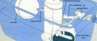
Level device:
- Collimator.
- The level mirror is round.
- Level.
- Lim horizontally.
- Treger.
- Screws for vertical displacement.
- Review tube.
- Adjustment screws.
- Micrometric screws.
- Lens cover.
Depending on the type of level, its final design may differ slightly from that presented above, but the basic elements + filling, which is 85%+ of the device, remain unchanged. The exception is optical devices, where the difference in assembly and components is felt much more strongly. To measure horizontal angles, a tripod is also used, which comes complete with a graduated dial.
Accuracy level of optical level according to GOST 10528-90:
- high. Fluctuations of less than half a millimeter per kilometer;
- average. Fluctuations are allowed per 1 km up to 3 mm;
- technical. Changes of up to 1 cm per 1 km are allowed.
In terms of materials in the assembly, preference is given to aluminum - this metal combines low weight with a fairly high margin of safety, which facilitates transportation and does not harm the strength of the structure when installing equipment. Alternative materials can also be wood and fiberglass. The first tripod option will cost more, while the second is suitable for small tripods.
How to cook aluminum with argon
2) Classification of levels
The weight of the level depends on its type and purpose. Household ones are lighter, specialized ones are heavier. In terms of weight, this range is between 500 grams and 3 kilograms. Using auxiliary equipment (tripod), the weight of the kit increases by 1.5-2.5 kilograms and can reach 6 kg.
The dimensions of the levels are also variable. I can indicate the average values - 150 in length, 130 in width and 210 in height. Fluctuations may vary depending on the model and reach 50% of the specified values. Parameters can change both up and down. Now let's take a closer look at the classification.
| Type + photo | Description |
| Optic | The basic area of use is repair work on highways and roads in general for any purpose. The tool is used to calculate the difference in height between extreme points. The second function is to determine the distance. The angular inclination is calculated using a graduated scale, which is marked on the lens glass. To correctly position the level to the horizon, a person will need to use a bubble-type level. To prevent any fluctuations from affecting the accuracy of measurements, the equipment is equipped with a magnetic damper or an air compensator. The cost of the level starts from 9,000 rubles. |
| Electronic | The device can accurately measure the 2 parameters mentioned above. In addition to the components of the optical type of the device, the assembly includes a special rail, storage equipment and software for making accurate calculations. Automated work eliminates potential operator errors. A person’s job is to install (correctly) and press a couple of buttons to start calculations. The price of such a device will cost 90,000 rubles and more. |
| Laser | The equipment is often used as a home equipment, because its dimensions, in comparison with others, are compact. A laser level is used primarily when working with planes, the location of which should be made with low fluctuations in accuracy. Equally good in verticals, horizontals and when calculating inclined planes. Some level models are equipped with a plumb line, which makes it easier to measure angles of 90 or 45 degrees. |
The laser type of level, in turn, has its own division into 3 smaller categories, each of which differs in the principle of laser supply for taking level measurements. I decided to highlight these model variations in a separate list.
Types of laser levels:
- linear.
Compact and popular level for home use. The laser passes through lenses + prisms due to which light is refracted, and as a result, static lines are built in space vertically and horizontally. The opening angle of linear levels can reach 125-130 degrees. At a cost from 1,500 (economy) to 8,000 (semi-pro);
- rotary.
Area of application: open spaces with large distances. The level is formed thanks to a point beam, which produces high-speed rotation around an axis, outlining a plane. In strong sunlight, laser projection cannot be seen by the builder's eye, which is why the delivery set often includes a special reception sensor. The further such a laser level can measure, the more this affects the cost of the equipment. The price tag of economy models starts from 8,000 rubles;
- spot.
Rays emanate from the level in different directions, which, when they intersect with an object, place a point on it. The applicability of equipment is lower than other categories, but the price tag of this level starts from 5,500 rubles;
- 3D.
A special type of level with wide functionality, which is capable of projecting beams in 3 spatial positions. According to the price tag, such equipment will cost the builder the most - from 15,000 rubles.
The level is powered by a built-in (sometimes removable) battery. Depending on the volume, the service life from one refill varies from a couple of weeks to a couple of months. In the home version, laser levels can operate for up to a year without changing the battery. Pocket versions are supplied with finger-type power supplies.
In addition to classification by type, there is a distribution according to 2 more parameters. I will provide a more detailed analysis of the moment in the table below.
| Classifier | Components | Peculiarities |
| Control | Manual | Bubbles are used for tuning. All adjustment operations are carried out by the operator. For more precise positioning, screw-type verniers are used. |
| Machine | More than 80% of alignment adjustments occur automatically, due to built-in mechanisms in the device itself. Sensors + stabilizers can reduce the error by 10% -20% from the basic values that the level operator can tolerate. | |
| Combined | From the name it is clear that for stabilization 2 mechanisms are used at once - manual and automated (sensors + software). The level of automation of such devices varies between 45%-55%. The error reduction potential (difference with manual adjustment) is 5%-12%. | |
| Laser color | Green | Has proven itself well when working outdoors. Thanks to the wavelength of 530 nm, the operator can take measurements at distances of up to 1000 meters without significant problems. As the laser grows, the range of the device increases, but in sunlight the visibility of the green laser is significantly reduced. |
| Red | The red beam is commonly used for indoor construction work. The wavelength of such a laser is 630 nm (+/- 1% -10% depending on the device model). The range varies from 15 to half a kilometer. |
In addition to modern laser-based devices, hydraulic levels are sometimes used. Hydrostatic leveling is a fairly accurate method for measuring height differences, which is why it is still used in construction today.
Checking the level
It is logical that the accuracy of level measurements is important for construction and repairs of any scale. Periodic adjustment (adjustment) of its readings is prescribed in the operating instructions as a mandatory measure and has strictly regulated intervals.
Typically, professional levels are tested by special organizations in accredited laboratories. This can be done at home at any time and at minimal cost.
An approximate verification algorithm looks like this:
- The device is installed in a space where there are at least two opposite walls.
- The task of projecting a point with a reflection angle of zero degrees is given.
- The resulting point is fixed on the wall.
- The reflection point is set at 180 degrees.
- The resulting point is also fixed.
- The procedure is repeated several times.
- The spread of indicators (the distance between fixed points) is measured.
- Based on the results obtained and the permissible error guaranteed by the manufacturer and corresponding to the accuracy class of the device, a conclusion is drawn. If the parameters are exceeded, the focus position, beam thickness, etc. are adjusted.
Choosing a level: characteristics and brands
To choose the most functional and high-quality device for your needs, you need to focus on the method of operation of the tool, the maximum permissible error and the manufacturer’s brand.
If we talk about the country of origin, then the advantage belongs to German and Swiss brands. The most popular levels are from BOSCH and LEICA .
The following brands have also gained popularity and trust from users: Milwaukee , STANLEY , STIHL , SKIL , Speziallaser , Makita , ADA Armo .
Understanding labeling
Their alphanumeric designation will help you obtain the necessary information about a particular industrial level. We will provide a minimum of useful information in this direction.
N-05 is a high-precision level for measurements of the first and second accuracy classes. Equipped with an optical micrometer. The measurement error does not exceed 0.5 mm when monitoring an object located at a distance of 1000 meters. Scope of application of such devices:
- State geodetic networks;
- Laboratories and testing grounds;
- High-class engineering and geodetic work.
N-3 is a precision instrument. The measurement error does not exceed 3 mm when objects are located at a distance of 1 km. Popular for measurements of the third and fourth accuracy classes, as well as for most engineering and geodetic studies.
N-10 is a technical device. The measurement error of this device, according to the manufacturer’s warranty, does not exceed ten millimeters when examining objects at a distance of 1000 meters. Such devices are used in most landscape studies and assessments, as well as in road and civil engineering.
For reference If there is a compensator in the design of the level, the symbol “K” is added to the marking. If the device contains a dial, this is reflected by the “L” symbol.
Leveling class 4 using the middle thread method
To begin with, the device is brought into working position using a cylindrical or contact level. Then the telescope is aimed at the surface of the dark side of the rear rail, and the level bubble is brought to the “zero point” by elevator or lifting screws. The reading can be taken using rangefinder and middle strokes.
In the same way, you need to shoot while pointing the tube at the surface of the dark side of the front rail, and then at the surface of the red side of the front, and then at the surface of the dark side of the rear.
If you are using an optical device with a compensator, you should first of all install the device in the working position, and also check the normal working position of the compensator. And only after that begin the shooting process.
As you shoot, record everything in a field journal. It is most convenient to use a recorder storage device for this. If a difference in values of more than 5 mm was determined, then the measurements are carried out again, and the height of the instruments should be changed by at least 3 cm. At the end of the field work, calculate the discrepancies along the line between the original benchmarks. This value must be from 20 mm, all results must be entered into the increase sheet.
So, the features and operating principle of an optical level, which is often used in construction work, were discussed above. Currently, there is no alternative to such a device, so when carrying out geodetic work it will remain the most relevant for a long time.
How to use a household level
Even taking into account the fact that these laser devices create an aura of complexity around themselves, in reality everything is much simpler. Of course, depending on the implementation of certain works, there are some peculiarities, but nevertheless the algorithm here is something like this:
- Preparing the device (charging, connecting batteries, installing it on a tripod (if necessary).
- Horizon control. If there is automatic control, this item is not relevant. When manually adjusting using screws, we achieve absolute (if possible) horizontalness along the bubble level.
- Turning on the device.
- If you are faced with the task of orienting the floor covering relative to the center of the room or constructing a level for gluing “clothes” for the walls, the device will automatically provide control points (or the desired line). If it is necessary to build a horizon at a certain height, we use a tripod.
- To visualize inclined landmarks or markings on the ceiling, you will need to initially purchase a device with three beams or use a multi-position tripod.
If women are ready to call the one who invented the washing machine great, then men (who are not afraid of repairs and construction with their own hands) are more than grateful to the one who invented the laser level. Having such a device at hand, all work is done faster, more accurately, with better quality, and what else does a real master need!
How to choose a laser level for apartment renovation and more
What you need to know about levels?
• You can extend the operating time of the laser level on a single charge by turning off unused beams.
This battery saving will be especially useful for “gluttonous” rotary devices.
• Remote control support simplifies operation of the level on large construction sites.
Level with remote control
• Optical levels, depending on the design, can produce both normal and inverted images.
For the latter, a leveling rod with inverted numbers is produced.
When carrying out high-precision measurements, slats made of a special alloy - invar - are used.
Optical levels: rules of use
Leveling is the term most often used in geodesy. Its essence is to measure the difference in heights between predetermined (reference) points of a section of space. To perform the operation, special geodetic instruments are used - levels. The meter is supplied with instructions in which the manufacturer informs the user about the technical and operational characteristics of the model and how to use the level. In addition, you can learn how to work with the meter by watching a video on the Internet or reading the following text below.