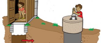
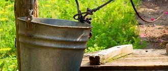
Many owners of land plots want to equip an autonomous source of water supply on their land. Finding water for a well on the site in this case becomes a rational solution to the problem. H2O of well origin makes it possible to satisfy the needs of residents for drinking and technical fluids without the use of a centralized system.
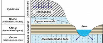
Places where underground moisture accumulates
Penetrating into the soil, precipitation undergoes natural filtration. They accumulate in soil layers, forming aquifers. These inland bodies of water not only lie horizontally, but also bend. This is how unique lenses consisting of an aqueous solution are formed. Their volume can vary from 3-5 to several tens of cubic meters.
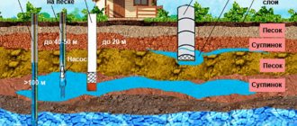
Deep deposits are of greatest value to humans in terms of use and consumption. The liquid medium in them is filtered in the best possible way. This high-quality liquid is found at a depth of 8-10 meters. If we consider not simple water, but enriched with mineral and salt components that are beneficial to human health, then it can be found no closer than 30-50 m from the surface.
Preliminary determination of well depth
There are several ways to find out the approximate depth of a well before drilling:
- Survey of neighbors in the area. If your neighbors use a well or well, you can always get this information from them. It’s even better if there is technical documentation for the well: it usually indicates not only the depth, but also the flow rate.
- Study geological research data. Such a plan is the result of engineering and reconnaissance activities carried out in the area. It contains information about the specifics of the soil and the pattern of aquifers. Having such documentation in hand, drilling a well is much easier.
- Test drilling. If accurate data on the depth of the aquifer in a specific area is required, exploration drilling can be ordered. This service is quite expensive and is used for private needs only in exceptional cases.
Test drilling
Classification
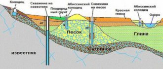
Before you start drilling, you need to find out how to find and determine the location for a well on the site. To do this, first of all, you need to find out how deep the aquifers lie within the designated territory. Depending on their location, underground pools are divided into three types.
Verkhovodka
Its deposits are located at a depth of 2-5 meters. Due to the nature of its location (near surface soil), the volume of the liquid medium is constantly changing. During the rainy season or during the snowmelt season, the level increases, during the dry period it decreases.
Groundwater
This type of water strata is located 8-40 meters from the surface. Their upper part is reliably protected by dense layers of rock. Therefore, the change of seasons and weather phenomena do not affect them. In some places with low relief, the liquid independently makes its way out in the form of springs.
Artesian
The deepest underground pools. They are located no closer than 40 meters from the surface layers of the soil. The deep water solution seeps through cracks in the rocky limestone deposits. During such filtration, H2O is enriched with trace minerals. This type of aquifer is characterized by the complete absence of clay impurities.
The quality and quantity of liquid play an important role.
When figuring out how to determine where to drill a water well on a site, people use various techniques to find water deposits. Some resort to the help of improvised equipment, others rely on the capabilities of modern technology. Hydrogeologists usually use preliminary exploration technology to determine the horizon and how deep the aquifers are located.
Where to begin
Water is found for drilling a classic well, a sand well, an Abyssinian well or an artesian well. Each method of raising water requires certain reserves located at depth. The higher the water lies, the easier it is to determine its location by indirect signs. Accordingly, the easiest way to find water is for shallow wells.
If you are planning to drill an artesian well, then indirect signs on the surface are unlikely to help, since water in limestone lies at a depth of 50 meters.
Having decided on the type of well, you need to find all the available cartographic material for the plot of land. Maps should be large-scale, that is, the more details, the better. If you are lucky, you can find a map of groundwater. At least such cards exist.
If you are just starting to develop an area where no one has built before, then it would be nice to have a vegetation map, from which you can find out what plant communities were once formed here before everything was cut down and dug up.
The influence of burial depth on quality
When driving a well in a place where, by definition, there is H2O, you can stumble upon it already 2-3 meters from the surface. In this case, we have verkhovodka, which cannot be used for drinking or cooking.
If the liquid medium is at a shallow depth, this is bad. It usually accumulates as a result of snow melting, infiltration of rain streams and water from nearby reservoirs (of questionable purity). In addition, it may contain wastewater from the sewer system. The qualitative characteristics of such surface layers leave much to be desired.
Due to its susceptibility to the influence of seasons and weather conditions, the perched water often completely dries up in the summer and refills only in the fall. Therefore, gardeners should not particularly count on such a well. In the hottest weather, there is a high probability of being left without watering at all, but after a couple of months it simply won’t be needed.
It is better to look for water deposits no closer than 15 meters from the surface. Sand layers are located at this level. The liquid is perfectly filtered through them, becoming tasty and clean. Sand conducts an aqueous solution through itself, removing harmful impurities and polluting particles from it.
How to search and find water underground in a well site: popular techniques
MBFT-75 Membrane for 75GPD
SF-mix Clack up to 0.8 m3/h
SF-mix Runxin up to 0.8 m3/h
There are many methods for detecting aquifers. The most common and effective of them should be considered in detail.
Barometric method
It is based on the use of a special device - a barometer. First you need to take readings on the shore of a nearby body of water. Then move with the device to the territory of the planned well base. Where there is to be drilling, air pressure is again measured. In this way, it is possible to determine at what depth the liquid medium lies.
So, if near a river or lake the value is 545.5 mm, and on the land plot itself it is 545.1, you will need to drill at least four meters. Since the calculation is based on the difference between two results obtained in different places.
Exploration by drilling
Exploratory soil drilling is one of the most effective methods for detecting underground liquid media. It is produced using a conventional hand drill. Since the exploration well goes to a depth of at least 6-10 meters, the handle is usually expanded during the process.
The location for the future well should be 25-30 m from drainage systems (trenches), garbage bins, compost heaps and other polluting objects. It is best to look for a good hill for this. Rain and melt liquid flow down.
Seismic exploration
It is based on the energetic “tapping” of soil layers with a special device. Sound waves penetrate the earth's crust and pick up response vibrations. Depending on the composition of the earth layers, wave impulses pass through them differently and return as damped signals. Based on their characteristics and intensity, the rocks and structure of deposits are determined, voids and accumulations of liquid are identified. When using this method, not only the strength of the return oscillations is taken into account, but also the time required for the return of energy flows.
The water solution and the rock reflect sound input in their own way. Based on this, it is possible to determine at what depth the underground water basins are located.
Determination of water in a well site using a search method based on energy waves is carried out simultaneously at several points. The received data is entered into a computer system and processed. Based on the results, the location of the presence of aquifers is determined.
Electrical sensing
It is used to detect liquid at a depth of 10-100 meters. With the help of special probing instruments, it is possible to detect the presence of a liquid medium according to the resistivity values of earth layers.
Four electrodes are driven into the ground in the form of pipes about 1.5 m in length. One pair creates an electric field, the second plays the role of a tester.
When the elements are alternately moved apart, the indicators are recorded. Based on them, resistivity and potential difference are determined. The value varies depending on how high the humidity is and what the composition of the earth layers is. Electrical sounding makes it possible to find out whether there are water deposits in a designated area and how deep they are.
Professional diagnostic methods ↑
Geophysical research ↑
How to check a well? Most often, specialists resort to geophysical research, during which they study not only water, but also the rocks adjacent to the walls of the mine. The technology is conventionally divided into two groups of methods:
- Borehole geophysics studies the features of soil in the inter-borehole space.
- Logging is aimed at studying the parameters of the rock adjacent to the well and the physical condition of the mine.
Well geophysical survey results
The first method is used quite rarely, so logging has become almost synonymous with geophysical research. Within the framework of this method, comprehensive well diagnostics is carried out using various techniques:
- Electrical logging. A probe with two electrodes is lowered into the shaft: one electrode is grounded at the mouth, the second moves along the shaft. Special equipment records changes in rock resistance and displays them in the form of a graph. The data is deciphered using tables showing the resistivity of each type of soil. The method has large errors, since there are no pure chemical compounds in nature, which means it is impossible to determine exact indicators.
- Lateral probing. Well diagnostics is carried out using two probes that show the resistance of the rock of the well itself and the surrounding soil.
- Induction method. Based on the magnetic properties of chemical elements. The entire periodic table can be divided into three groups that react differently to the influence of the electromagnetic field: ferromagnets, diamagnetics and paramagnets. An induction probe examines the “responses” of the rock, based on which conclusions are drawn about the structure and condition of the well.
- Gamma ray logging. The probe reacts to the natural radiation background of the rock, which makes it possible to draw conclusions about its chemical composition. The method is highly accurate.
- Acoustic method. Measures the resonant vibrations of the rock and determines its composition. The method is very labor-intensive, because each chemical element requires changing the equipment settings. Acoustics are most often used not for well diagnostics, but for searching for rare earth metals.
Geophysical methods are quite expensive and do not always provide a complete picture of the condition of the well. Therefore, recently they have been replaced by more modern methods, including television inspection.
Geophysical surveys can be carried out at any time of the year
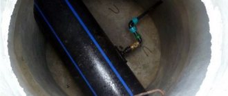
Well diagnostics with teleinspection systems ↑
Teleinspection allows you to check a well after drilling, as well as identify problems that arose during its operation. A waterproof video camera is lowered into the shaft and continuously records. The technology checks and evaluates:
- condition of well filters;
- level of sludge deposits;
- the degree of corrosion of the casing;
- leakage of tightness;
- actual well depth;
- static water level;
- presence of foreign objects.
It is recommended to carry out television diagnostics of wells when accepting new facilities or reducing the flow rate and water quality. Modern systems are equipped with high-resolution color video cameras that can detect the smallest defects in casing pipes, as well as assess the amount and nature of deposits.
Modern video cameras provide a very clear pictureImportant! Teleinspection with a two-module camera (direct and side view modules) is more expensive, but provides better diagnostics.
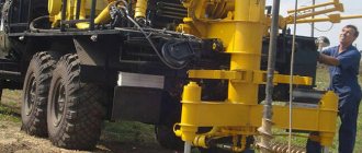
Common Drilling Techniques
There are several main ways. Each of them must be considered separately. This will make it possible not only to find out how to determine the location for a water well on the site, but also how best to get to the deposits.
Core method
It is used to detect particularly deep underground layers of liquid (100 m from the surface or more). A special rotating pipe deepens, and the washing base is supplied in parallel. A strong stream washes away the soil and throws it up. When drilling into a water-resistant layer, compressed air is used to avoid flooding the horizon.
The advantages of this technique include:
AMETHYST - 02 M Residential building for up to 10 people or up to 2 cubic meters/day.
Aeration unit AS-1054 VO-90
Main table dispenser AquaPro 919H/RO (hot and cold water)
- increased productivity;
- the ability to reach great depths;
- passing particularly hard rocks without difficulty.
Auger drilling
Relevant for not too deep underground water basins. A special feature of this method is the ability to remove mined rocks from the hole being punched. The earthen elements rise to the surface on the flange of a rotating auger. At the end of the steel rod there is a chisel. In the process of screwing into the ground, it breaks it into parts and lifts it up.
The main advantages of the method are:
- low cost;
- high immersion speed;
- no barrel flushing and no need to lift for cleaning.
Shock-rope technique
Used primarily for the development of particularly hard rocks. The impact projectile is attached to a strong steel cable held by a towering mast-shaped structure. As it moves, the rock layers are broken, creating an exploration hole (hole).
Garden hand auger
Landowners usually use it independently. Without resorting to outside technical assistance. It is quite possible to drill 15-20 meters deep with it. When deepening, it is necessary to periodically check the soil for moisture levels.
Each technique described above allows for exploration or direct drilling. The selection of suitable equipment should be based on financial capabilities and geological features of the territory.
We are trying to drill for water
Today, folk methods are gradually moving aside, giving way to technological progress. Searching for water using technical means is less exciting, requires financial expenses, but gives more reliable and accurate results.
Best place to drill
The simplest and least expensive way to check the presence of water on a site is exploratory drilling. Test wells are drilled in several places. Water is everywhere, the task of test drilling is to find the least deep places.
Test drilling helps to avoid unnecessary financial expenses, since exploration wells are cheaper than production wells. This is due to the small diameter of the hole and the use of lower power equipment. In the absence of sufficient confidence in the availability of water, the construction of a full-fledged production well is not economically feasible.
Test wells up to 10 m deep are drilled with an ordinary garden drill. Periodically, the drill is removed from the well and the degree of soil moisture is checked. At great depths, auger units and a drill with a chisel are used.
Test drilling with a garden auger
The accuracy of testing is greatly influenced by the professionalism of the driller, so it is better to invite a qualified worker to carry out drilling. A water sample from the aquifer is sent for analysis of the content of harmful impurities.
The disadvantage of test drilling is that it is almost impossible to estimate the parameters of an underground source. Well fill rates or production rates at wells located on the edge of a fault zone or aquifer may be extremely low.
How to look for water for a well using plants
Representatives of the flora are ideal indicators in the search for underground aquifers. Any tree or shrub is adapted to certain environmental conditions. They can only grow where the soil is most favorable.
Height and roots
A small tree requires very little moisture to survive, but a tall tree does the opposite. Therefore, the presence of tall objects signals that there is H2O underground. Specimens with a tap root system are able to penetrate deep into the soil, reaching the ground. If there are many similar specimens in the area, it means the liquid is nearby.
It can be located at a depth of about 10 meters. By the way, tall, dense grass is also worth paying attention to. Its presence is a sign of the occurrence of an underground liquid medium.
Varieties
In relation to H2O, all plants are divided into a number of categories. To study the area for the presence of underground pools with an aqueous solution, only two of them are important: moisture-loving and drought-resistant.
The larger the leaves of a tree (shrub), the more moisture it needs to regularly consume. Accordingly, if such representatives of the flora grow on the site, it is very good. It will be possible to detect water deposits without much difficulty.
Plant groups
If in a certain area several large plants grow in one group at once, underground pools are very close. The best indicator in this regard is the well-known poplar. Where there is a lot of it, there is liquid underground.
It is noteworthy that birch and oak trees are not such an indicator. They almost always do not signal the occurrence of water layers near the surface.
Where can you dig a well?
It is not enough to determine a place to dig a well on the site. Strict rules for its location must also be followed to ensure safe and high-quality water production.
Rules for determining where to dig a well or borehole:
- The source of drinking water should not be located closer than 20-25 m from breeding grounds for soil pollution - garbage dumps, rotting products, toilets, cemeteries, and so on. Otherwise, harmful substances may enter the source of moisture, which will infect it with pathogenic bacteria.
- It is necessary to protect buildings on the site from flooding, so the well structure is placed at a distance of 10-15 m from all buildings. Neighboring buildings are also taken into account when locating the well.
This distance is optimal. If a plot near the water is endowed with the standard four hundred square meters, densely planted and built up, then it is difficult to comply with such a norm. In this case, it is allowed to remove the water source from the cesspool or toilet by about 10 meters.
According to regulatory documents, when looking for a place to dig a well on a site, you should avoid:
- regularly flooded areas;
- wetlands;
- close proximity (less than 30 meters) to highways.
These rules must be observed when constructing mine wells; if you plan to dig a deep well, then the distance of the source from other objects is reduced.
If the soil on the site is clayey, then the issue of remoteness is also not so acute. In this case, you need to take care of thoroughly insulating the walls by constructing an upper protective well ring. This measure allows you to protect water from various contaminants during snow melting and rain, when streams of precipitation from the ground surface can fall into the well.
How to determine the presence of water when drilling a well with your own hands
There are a lot of traditional methods for determining the presence of H2O underground. Each of them is very specific, but at the same time has been tested by more than one generation. Whether they are useful to you or not - decide for yourself.
Main table dispenser AquaPro 929CH/RO (cooling/heating)
Floor dispenser AquaPro 311 (empty, without cooling)
Floor-standing dispenser AquaPro 6207CH (cooling/heating/room temp.)
Silica gel
A clay pot filled with this substance is tightly wrapped and buried about 1 meter into the soil. Before instillation, the container with the contents is weighed. A day later, it is taken out and weighed again. The heavier it became (accordingly, it absorbed more), the closer the aquifer.
Search technology using a vine
The process involves walking around the area with a willow branch. Initially, it is necessary to dry a suitable bifurcating branch (with two branches). Then you need to take the edges of the “slingshot” in your hands, spread them apart 150 degrees, trying not to break them. The main reciprocal part should look slightly upward. With this simple structure you should walk slowly around the square. Where the corner goes down, there is underground liquid.
Considering the development of modern technologies, this method of finding water in the mountains and drilling a well afterwards is quite dubious. Nevertheless, our ancestors previously relied on it.
Ancient method with clay pots
Clay vessels have long been used to detect underground water layers.
First of all, the dishes were thoroughly dried. Then they installed it in the place where they were going to drive the well upside down (bottom up). If droplets of moisture appeared on the walls of the container by morning, it means that the liquid medium is very close to the surface.
Service Animals
Representatives of fauna are no less sensitive to the presence of H2O in the ground. Thus, dogs and horses have a habit of digging up the soil where there is a high probability of aquifers nearby. Chickens, on the contrary, will not lay eggs in conditions of high humidity. In places where they lay, as a rule, it is very dry, there is no liquid nearby. The same goes for ants. Not a single anthill will be built on a “wet” site.
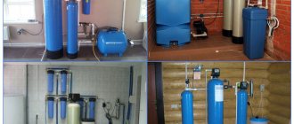
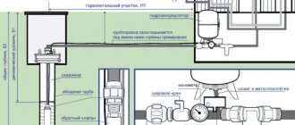
To make H2O truly potable and healthy, it is necessary to install a treatment facility after the well itself has been constructed. It offers consumers a wide range of filtering devices. For many years, we have been producing water treatment equipment and providing its installation, as well as warranty service. Customer reviews of the products are extremely positive.
With salt and brick
Another old-fashioned trick. During the dry season in summer, you need to pour regular table salt or brick chips into an unpainted clay pot. Everything should be weighed together and the indicators recorded. Next, you need to wrap the container with the contents in cloth or gauze and bury it 0.5 meters. After a day, take out the vessel and weigh again. If you get very heavy, moisture is nearby.
How to find a place for a well using a frame
To implement this method, you will need two pieces of thick aluminum wire. Each segment must be bent on one side (made into the letter “G”). You first need to cut something like handles from the wood of the viburnum tree. The core should be removed from the workpiece so that the metal can rotate freely inside. We insert the ends of the rods into wooden holders and walk around the area with a homemade device in our hands. The wire ends should not touch. Where the underground pool is close to the surface, they will turn directly in that direction.
What kind of research is this and when is it needed?
Well water analysis is a complex of physical and chemical. laboratory activities aimed at confirming or refuting the safety of water in chemical and bacterial (epidemic) terms.
It is carried out for the following purposes:
- determining the suitability of water for drinking and its harmlessness;
- obtaining information of interest about the chemical and bacteriological composition of water;
- to select a filter system and determine its effectiveness.
In addition, the basis for the study may be:
- sale or purchase of real estate;
- the appearance of problems with digestion and allergies;
- changes in the appearance, taste and smell of water;
- deterioration of environmental conditions in the area of residence.