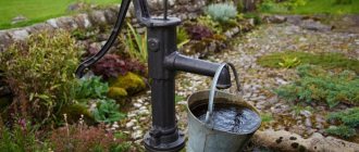
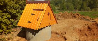
Having a well on a personal plot is a vital necessity. Even if you have a car, it is extremely inconvenient to deliver water to your dacha in cans and bottles. Digging a well is quite a feasible task, but here you need to arm yourself with knowledge, since you will have to master methods for determining where exactly to look for water and how to correctly position the well shaft in terms of sanitary norms and rules.
Where to begin?
It is recommended to start searching for water in a well site by examining the area for the presence of springs and springs. Do your neighbors on the property have a well? The presence of both of these signs indicates that aquifers can be found on your site. You can also study where aquatic indicator plants grow. For example, the abundance of woodlice indicates the close occurrence of groundwater. Mark the proposed search area in accordance with sanitary standards for distance from the septic tank.
ATTENTION! In areas with a slope, you need to look for water for the well in its lowest part.
Practical methods for finding a water carrier
Popular and effective methods of searching for water are indication with dowsing frames and special equipment.
Dowsing frames
The dowsing method is widely used to quickly search for water-bearing areas. It uses special frames made of aluminum and wicker.
You can make frames for finding water from aluminum wire as follows:
- Thin aluminum wire is cut into two equal sections of 42 cm, with each section bent 16 cm, forming right angles.
- A wire is inserted into pre-prepared hollow tubes (made of elderberry) for free rotation around its axis. One tube - one wire.
- The finished frame of two tubes is taken in both hands, with the corners of the wire turned in different directions. When an aquifer is detected, the wires come together. If the wire is located on the right or left side of the person, both ends of the wire will turn in the right direction. If the core is missing, the ends of the wire will diverge in opposite directions.
Many owners prefer dowsing, when an ordinary vine is used to find water.
A wicker frame is made as follows:
- A branch is cut from a tree with a fork in the shape of a slingshot. In this case, the branches should be located towards each other at an angle of 150 degrees.
- The workpiece is dried thoroughly over several days.
- The finished frame is taken in both hands so that the common barrel is directed upward.
- Next, you need to carefully examine the area with the vine. Near the location of the aquifer, the trunk will begin to pull down.
Searching for water using a vine is quite successful; as you know, the vine is a moisture-loving plant. To understand how to properly organize dowsing and search for water in a suburban area, you can watch the video.
Aneroid barometer
If there is a natural reservoir or any hydraulic structure near the site, you can use a device to find water - an aneroid barometer, designed to measure pressure. The pressure changes taking into account the difference in height - 0.1 mm of mercury for every meter of depth.
Using the device, you can determine the level of the water carrier. First, pressure is measured on the land plot for the well, as well as near a reservoir or hydraulic structure. The change in pressure determines the depth of the water layer.
Exploration drilling
A more labor-intensive way to find a water carrier is exploratory drilling. For the work, a compact motor drill is used, which is intended to determine the composition of the soil, the presence of groundwater and its level.
If there is no drilling rig, drilling can be done using a bailer - a hollow pipe equipped with an end valve. Drilling is performed using the percussion-rope method.
Any owner can determine a suitable place for constructing a well or a well on the site by choosing the most effective method.
What horizons are suitable for a well?
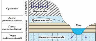
When searching for water for a well, they stop at either high water or groundwater aquifers.
- Soil water or perched water is suitable for technical and agricultural needs, but is completely unsuitable for drinking. They can be found at a shallow depth of a meter and a half, especially if the area is low-lying or is located in close proximity to a river or stream.
- Groundwater begins after one and a half meters. While soil waters are not filtered, spilling between loose-grained layers of the earth, groundwater is held between layers of water-resistant loam and clay, rocks, limestone, and layers of sand. These multi-level layers are good natural filters, purify water and make it suitable for drinking, and do not allow harmful pollutants to enter the aquifer.
If you decide to make a well not only for domestic needs, but also to provide your family with drinking water, you should take groundwater no higher than 10 meters; the ideal option is a well fifteen meters deep.
Layers of soil, sand, stones, and clay form an internal structure with gaps and cavities of different sizes, in some places the voids are very narrow, and in other places bends are created like lenses or gaps that are filled with groundwater. These places have an abundance of water, and in narrow interlayer cavities the volume of water is minimal.
Groundwater and soil waters have no pressure; only in rare places, groundwater aquifers, sandwiched by impermeable layers, can be characterized by small pressure values.
FACT! Groundwater has an undeniable advantage. They are not only clean, but also access to them is stable, unlike perennial water, the volume and presence of which directly depend on the amount of precipitation and time of year. Also, the perched water is easily contaminated by the leaching of fertilizers from agricultural land during periods of snow melting or heavy rains.
Water underground
The regime of groundwater is the changes that occur with it depending on the season, precipitation, anthropogenic and geological processes. Their quantity and composition depend on all this.
Formation of underground horizons
There are several theories about where water underground comes from. All of them have a right to exist, since observations show the presence of all of them. The whole question is the proportion of active factors in different aquifers. The following ways of formation of underground aquifers are distinguished:
- Infiltration. Moisture seeps down after precipitation and flows through cracks and capillaries.
- Condensation of water vapor from the atmosphere in rocks.
- Sedimentation, when a surface water basin is closed by rocks during geological disasters.
- Endogenous formation of water. It occurs at great depths, where pressure causes sedimentary rocks to become metamorphic. This releases H2O.
The speed of these processes varies, as do the formation features in a particular region. Thus, in mountainous areas where there was violent volcanic activity in the past, the water becomes mineralized as it moves down. In other places, mineralization is less developed, but still occurs. In this case, neighboring aquifers may have different chemical compositions.
Aquifers
An aquafer, or aquifer, is a layer of sedimentary rock that is characterized by a certain permeability to water. These layers are delimited by waterproof layers, most often clay. The layer above the aquifer is called the roof, and below it is called the base.
There are various classifications of aquafers, but among them the interesting ones are those that have the greatest economic importance; Legislative regulation also plays an important role.
Aquifers are divided into:
- Pressure, or interlayer. They are under pressure and located at depths that require drilling. The pressure can be high, and the well will flow out. Such waters are called artesian.
- Gravity, or ground. These waters are subject to aeration because they do not have a waterproof roof.
The first type of water is a mineral resource, and a license is required for its extraction. The second one you can take in any quantity. The legislation regulates the intake of water that serves as a source of centralized water supply, and this is artesian water.
This is not to say that aquifers do not communicate with each other in any way. In practice they are always interconnected. Any interstratal layer has a feeding area, a pressure area and a discharge area, while feeding is carried out precisely due to ground moisture. The unloading area can be represented by several options:
- a source coming to the surface;
- infiltration of artesian water into groundwater at the site of a roof rupture;
- underwater springs feeding reservoirs; There are entire lakes with exactly this type of nutrition.
Thus, the upper aquifer, which occupies an intermediate position between the surface and interstratal ones, serves as a source of nutrition for both and depends on them.
In one of the villages, the owner of the site decided to drill a well “into the sand.” The plot was purchased not so long ago and transferred from the category of agricultural land to the category of individual housing construction. After drilling, water came out of the well, but it was not suitable for drinking or watering the garden: the salt content exceeded all limits and, in terms of the degree of mineralization, the water fit the concept of “medicinal.” There was a mineral water discharge zone nearby, but the owner did not take this into account. As it turned out, he was only mistaken by two meters.
What are the sanitary requirements for the location?
The water intake point should be located at least fifty meters away from toilets and cesspools upstream of the groundwater flow. Otherwise, there is a high possibility of mixing harmful substances into the water and contaminating it with pathogenic bacteria.
This is the optimal distance. If the personal plot of an ordinary summer resident is four hundred square meters, densely planted and built up, then such a norm is difficult to achieve. In this regard, there is an opinion that it is quite enough to make a well at a distance of about 8-10 meters from the toilet and cesspool.
INTERESTING! If the soil on the site is clayey, then such distance should not bother you at all. Especially provided that you take all possible measures to insulate the walls of the well, also constructing an upper protective well ring that protects the water from possible contamination during rains and spring melting, when water flows can flow into the well from the surface of the earth.
According to regulations, when looking for a place for a well, you should avoid:
- Frequently flooded areas.
- Wetlands.
- Close proximity (less than 30 meters) to public roads and highways.
Foundations and water
During construction, it is necessary to take into account both the groundwater level and the composition of water and soil. The most important parameters influencing the type of foundation structure and materials used are the ratio of groundwater level and freezing depth, as well as the chemical properties of water.
Determination of burial depth
Many people living in central Russia are familiar with the phenomenon of frost heaving of soils. It is caused by the freezing of moisture in the pores and capillaries of loams and sandy loams. Sand and rocky soils are not prone to heaving. The forces of frost heaving can destroy an improperly laid foundation.
If there are such soils on the site, two parameters should be determined: the freezing depth in your area and the groundwater level. If groundwater is located below the freezing depth, the base of the foundation can be located above it, as far as the bearing capacity of the soil in relation to the weight of your house allows. For high groundwater levels, there are several solutions:
- The base of the foundation can be placed 20 cm below the freezing depth. This solution is applicable for heavy buildings, which is due to the greater load-bearing capacity of the underlying layers.
- You can lower the water level by draining the area and draining it into a storm drain. This measure has worked well where such a sewer system exists or is easy to construct.
- Raise the level of the area using crushed stone and sand so that the groundwater level is below the freezing level. A forced and expensive measure, but there is no alternative where the site is located in a lowland.
- Insulate the soil near the house using heat-insulating slabs, and compensate for the insufficient load-bearing capacity with the width of the sole, up to the filling of a single monolithic pillow.
Concrete for aggressive environments
Complete protection against chemical aggression has not yet been invented, otherwise all reinforced concrete structures would stand forever. But some measures will help extend the life of your underground structure. They are designed to protect the structure from moisture penetration and reduce the negative impact of the latter if it does leak inside.
- Pay attention to the density of the concrete. Not only correct kneading is important, but also vibration. The laid concrete should not have pores or cracks.
- Do not use crushed limestone if you have acidic soils. Mix concrete using granite; although it is more expensive, it is much less susceptible to the effects of acid.
- Good waterproofing of the foundation is the key to its long service life. Carefully insulated foundation walls do not get wet. It is better to start waterproofing measures with a base in the form of a screed, which should be treated with bitumen mastic. This way you will achieve greater tightness.
- If you are unlucky and your area is “rich” in sulfuric acid salts - sulfates, there is a solution for you. It is in cement. Currently, four types of sulfate-resistant cement are produced. It minimizes the content of iron and aluminum, so concrete made with such cements does not break down even in sea water. Its cost starts from 300 rubles per bag, which is not much more expensive than ordinary Portland cement.
If you want a house with a basement, try to get rid of excess hot water on the site. No matter how carefully you protect your foundation, believe me, water will find a hole.
Traditional methods
These are the simplest methods of finding water, based on centuries of experience.
Observations of natural phenomena
In the warm season, in the early morning hours or in the evening, observe where the fog is thickest. The thicker the fog cloud, the closer the groundwater. This observation is justified by the fact that fogs are formed from earthly moisture, and in places where subsurface water accumulates, the fog is usually thicker; it literally swirls from the soil in such areas and spreads along the ground.
Observation of animals and insects
Dog owners may notice that their pets, in the heat, dig holes and lie down there to cool down. Animals sense where the coolest, and therefore wetter, places are. This temperature feature is also caused by the proximity of aquifers.
Midges and various midges also sense such places; they gather in flocks and swarm in the late afternoon where there is increased soil moisture.
Plant observation
Plants, as well as natural phenomena, and animals and insects can help in finding water for digging a well. The presence and proximity of aquifers can be judged by the following grasses, shrubs and trees.
- Hemlock, an abundance of nettles, thickets of sorrel and coltsfoot can be found precisely on consistently moist soil fed by groundwater.
- Birches, willow bushes, and alder love moisture and grow well only in places rich in water.
- But apple or cherry trees do not like wet soils, and their presence indicates that water cannot be found nearby. Of course, we are talking about healthy and abundantly growing trees. If the trees are sick and frail, the possibility of finding water-bearing veins is higher.
- find the aquifer veins above.
The depth of the water layer is determined by plants:
- Sandstone reeds, for example, can tell you that the water is a meter or three from the surface.
- The reed suggests an aquifer at a depth of one and a half to five meters.
- Wormwood from three meters to seven meters deep.
- Licorice from one and a half meters to ten.
- Alfalfa is from one and a half to two, but sometimes up to 15 meters.
Dowsing method
They are trying to link this method to the scientific field, which is fundamentally wrong. From this point of view, the previous information is much more useful than this method. However, he has his fans and for good reason. The emphasis is on the presence of energy information fields of various types in the surrounding reality and a person’s ability to sense these fields.
In the old days, the method had no competition and no alternative, now the possibilities of science are very high, and this entertaining method is still firmly one of the first in the popularity ratings. It would not be true if we said that the dowsing method is ineffective at all, but its infallibility does not correspond to reality either.
Since it is not always possible to use expensive services for searching for water resources in the soil, you can try it. It is better if you make an initial determination of the search location using tests with plants and animal behavior. Analyze the area from the point of view of geologically expected aquifer zones (the presence of lowlands, ravines, proximity to water intake points and springs).
Dowsing technique using aluminum frames
Manufacturing:
- The total length of the aluminum rod is about 90 cm, its diameter must be at least 3 mm.
- Having measured 15 cm from the edge, you need to bend the rod at a right angle.
- Insert the short ends into the tubes; any option will do for this.
- The diameter of the tube should be such that the rods rotate freely and move, but not at an angle.
- Take tubes 0.5 mm wider than the diameter of the aluminum wire.
- You need to make two such bent rods and insert them into the tubes.
Using frames to find water
Aluminum frames are held in both hands.
At the same time, it is very important to tune in to the search process. Let go of everything and wonder about the location of the water, completely shifting your attention to the frame.
Your hands should not be too tense; too much relaxation will also ruin the process. It is necessary to reach some golden mean.
The frames should become an extension of the person, a part of his attention, his being. It's like a kind of meditation with concentration on a specific task.
When the desired feeling of immersion and concentration occurs, a person should begin to slowly move around the site, snake-like across its entire area, testing the territory.
At the stage of finding the aquifer zone, a marking stick is driven into the area of land indicated by the frame.
It is believed that in places where there is water, the frames come into active motion.
Using a framework to determine the depth of a water resource
- From the marking peg, the footage is laid out using a tape measure in a straight line on the surface of the earth.
- Next, they begin to determine the depth of the aquifer. To do this, they slowly walk along the laid out building meter with frames, testing at what depth the water lies.
- The mark at which the frames become active and begin to spin and sway from side to side is considered a measure of depth.
Properties of water in soil
Since it is the unconfined formation that people most often encounter, it makes sense to talk about it.
Unconfined aquifers have varying thicknesses. It is determined by the average distance from the waterproof base to the upper level, which can be observed in wells.
Ground water level
This is not a constant value. How far the water will be from the surface of the earth depends on several factors:
- amount of precipitation;
- the water level in the reservoir to which the specific horizon belongs to the watershed;
- season;
- availability of mining sites nearby;
- land reclamation;
- availability of drainage systems.
Thus, the groundwater level increases in the spring, when seasonal permafrost thaws and floods begin. During heavy rains, it also increases, but the rate of infiltration of precipitation, forming the so-called perched water, depends on the permeability of the soil. For example, sand absorbs moisture quickly, while loam absorbs moisture slowly. The soil between the earth's surface and the upper water level is called the aeration zone, and everything below is the saturation zone.
At a higher level, forests maintain moisture. Moreover, the regime of groundwater and surface water in the area of river valleys is closely interconnected. If forests along the river are cut down, the river gradually becomes shallow; This affects both the reduction of the catchment area and the clogging of the riverbed by coastal rocks during precipitation.
The reduction of groundwater level is facilitated by the extraction of mineral resources and the installation of drainage systems, and in the second case this is done purposefully, and in the first it is a side effect.
Chemical composition
As you know, distilled water is only available in laboratories. The underground has a different amount of minerals, and according to their content it is divided into five degrees of mineralization:
- fresh, with salt content up to 1 g/l;
- slightly salty, 1−3 g/l;
- brackish, 3−10 g/l;
- salty, 10−15 g/l;
- brine, more than 50 g/l.
Not only the amount of dissolved substances, but also their composition is of practical importance. It depends on the composition of the filtering soil layers and the hot water regime. Thus, the chemical composition of waters with different directions and flow rates is different.
Some components contained in water can destroy stone, metal and concrete. The rate of destruction varies, but in any case, an aggressive environment reduces the service life of the underground part of the building, so a study of the chemical composition of water should be carried out before laying the foundation.
The standard indicator of medium acidity for concrete structures is pH=6. Lowering or exceeding it is fraught with destruction of metal and concrete. This is caused by the activity of the following substances:
- Carbon dioxide. It can leach both calcium carbonate CaCO3 and hydroxide Ca (OH)2 from concrete. The unbalanced content of carbon dioxide in the soil leads to the fact that the foundation part gradually “loses weight”, losing calcium.
- Sulfate ions. Sulfuric acid salts strongly dissociate in water, and SO4 ions react with concrete components, which increase in volume (swell).
- Magnesium chloride MgCl2 enhances the effect of carbonic acid, forming water-soluble calcium chloride.
- Free oxygen. An increased amount of it leads to metal corrosion.
- Salts of sodium, potassium and other metals.
The concentration thresholds for these substances vary greatly. It all depends on the filtering capacity of the soil and the type of concrete used.
The reasons that increase the aggressiveness of hepatitis B are most often natural phenomena. Thus, the abundance of limestone in the soil cannot but affect the content of calcium and carbon dioxide in the water, and the presence of a swamp makes it acidic. Human activities also influence the chemical composition of humic substances; sometimes it is direct, especially in areas where industrial mining enterprises are located, and sometimes it is a consequence of a lack of knowledge.
In coastal areas you can encounter the phenomenon of salt water in wells. It arrives there in cases where fresh water is pumped out uncontrollably and water supplies are replenished by infiltration from the sea. The closer the source is to the sea, the less time the water has time to free itself from salts and over time it becomes unfit for drinking. In this regard, some countries, for example, Israel, control the level of HS, which is very important in arid climates.
Alternative methods
In this case, a number of methods are used, aimed at measuring the level of humidity at different points of the site. Where there are aquifers, the humidity is significantly higher. To do this, use silica gel, brick, salt, earthenware or glass jars.
Method using desiccants
- Take a moisture-absorbing substance, for example table salt, silica gel.
- The substance is dried in an oven, poured into a dried, unvarnished clay container, wrapped in a piece of natural fabric.
- All this is weighed on precise scales.
- Usually about a dozen such testing “devices” are prepared. Each one should be signed so as not to make a mistake when re-weighing.
- Next, the containers are buried at a depth of half a meter to a meter in the ground.
- After 24 hours, the weight is re-determined.
IMPORTANT! The more the weight of the indicator increases, the higher the probability of the presence of water at a given point.
Manipulations with brick, lime and salt are done exactly according to the same principle.
Glass jar method
- Dry glass jars without lids are placed upside down throughout the water search area.
- After a few hours, the jars are inspected.
- Where the inner surface of the jar has become heavily moistened and a high percentage of condensation has accumulated, water is expected to be found.
Scientific ways
The most reliable methods for exploring water in a personal plot are scientific methods. They are all based on physical principles.
Spectral seismic exploration
An impact influence on the earth's surface is organized and a special seismic-sensitive device records response impulses and oscillatory signals.
This information is entered into a computer and, using a specially created program, calculations are made about the probable location of the water. Seismic instruments allow you to scan the bowels of the earth, identifying their structure, bends, layers, the presence of voids, as well as the level of occurrence of aquifers.
The method is very expensive and is only suitable for search activities in large-scale projects.
There is also a set of existing geophysical data about certain areas; these inquiries can be made with the help of specialists in the field of hydrogeology and geophysics, they can also help in finding water.
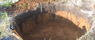
Manual drilling
They use a hand-held garden drill with a diameter of thirty centimeters. Test wells are made from five to ten meters deep. After inserting the drill into the soil, deepening the auger, remove the soil every 15-20 cm and inspect it in order to protect the drill from breakage and check the moisture level as an indicator of the proximity of the aquifer.
The method is effective and, unlike seismic exploration, accessible to private individuals. The percentage of accuracy and efficiency here largely depends on the professionalism of the driller.
Impact on construction
The design of any structures that involve pouring a foundation should always begin with measuring the groundwater level. The higher their location, the less the soil can support load-bearing supports. If the underground aquifer is located at a depth of less than 2 meters, then this is considered a high groundwater level. Given their location, construction that requires the construction of a pit or trench should be abandoned.
Diagram of a test well to determine the groundwater level.
It is also worth avoiding construction if, at a high groundwater level, there is sandy soil with silt between the surface of the earth and the aquifer. Moisture entering the layers of sandy rock will cause the soil to change (it will begin to “float”), which will adversely affect the ability of load-bearing structures to withstand the loads created by the building itself. If there is a layer of shale at this level, then the ingress of water into it will lead to its softening, due to which the stability of the soil will be lost, which will inevitably contribute to the curvature of the foundation level.
In any case, if such problems exist, the cost of development will be unreasonably high. The fact is that underground water will constantly fill the dug pit, even with high-quality waterproofing and drainage, which will not allow pouring the foundation. Such measures will only provide the necessary effect for a short period of time, but the groundwater itself will not disappear and, after a short period of time, will again restore its original level.
The level of the underground aquifer causes restrictions in the form of the choice of foundation, its depth, size and construction time. In addition to these indicators, the level of the underground aquifer imposes restrictions on the choice of materials for construction and their technical characteristics (density, strength, water resistance, etc.). The decision to arrange plinths and basements also directly depends on the groundwater level.
Scheme for lowering groundwater.
Therefore, in construction, the standard distance from the base of the foundation to the underlying groundwater is 0.5 meters or higher. This will make it possible to equip all load-bearing structures in accordance with the standards and guarantee the reliable operation of the constructed building. If the calculation was carried out without taking this norm into account, then uneven heaving of the soil will occur, resulting in a skew of the foundation, which will cause cracks to appear in structures, which can lead to their collapse. That is why the groundwater level must be determined at the building design stage.