The depth of soil freezing directly depends on the type of soil, climatic conditions of the area, groundwater level, vegetation, snow level, terrain, soil moisture and other factors. The parameters and features of freezing must be known and taken into account when drilling wells in different areas of the Moscow region.
The depth of soil freezing is a random variable that cannot be constant, because some factors above the above factors practically do not change over time - this is the type of soil, terrain, while others, on the contrary, are constantly changing - this is the height of the snow cover, humidity soil, duration and intensity of sub-zero temperature, groundwater level and others.
What is soil freezing
Soil freezing - expansion of the soil, compaction of the earth due to the conversion of moisture into ice crystals. The process itself occurs differently, depending on the type of land, region, and depth. This factor affects the functioning of the well; frozen soil causes horizontal and vertical displacement of the concrete rings. If there are cracks or breaks in the formwork, water penetrating into them freezes, bursting the concrete, which will lead to expensive repairs.
Soil freezing for water pipes and septic tanks
To lay water supply pipes, the depth of soil freezing is taken into account, SP 131.13330.2012, corresponding to specific regions.
If regulatory requirements are not met, water freezes in the pipeline in winter. If it is possible to warm up the pipes at a summer cottage, then city residents can only wait for spring.
When laying the pipeline, the following factors are taken into account:
- type of soil;
- frost line;
- depth of groundwater passage;
- minimum temperature limit in winter;
- heating the soil by the sun's rays;
- snow thickness;
- the presence of green spaces;
- functionality of the plumbing system;
- water circulation and temperature;
- the rate of soil freezing at subzero temperatures.
Failure to comply with basic requirements during pipeline construction leads to ice spreading along the pipeline, pipe rupture, and pump failure.
Types and characteristics of land
From the diversity of land cover, we highlight the main ones with opposite characteristics:
- Loam - 60-70% consists of clay layers with admixtures of wet sand. This type of cover has low plasticity.
- Sandy loam is loose soil consisting of sand particles with a small concentration (5-15%) of clay particles. Probably the most common option in the Moscow region.
- Peat, bulk layers - are located in former riverbeds and reservoirs. On these types of cover, the construction of wells, their deepening, and subsequent operation is problematic, this happens due to the plasticity that provokes deformation of the rings and water pipes from the hydraulic structure.
- Saturated clay - like the previous type, clay is characterized by plasticity and the ability to accumulate moisture and water. Water freezing in the soil causes heaving, putting pressure on reinforced concrete rings and water supply pipes if they are installed above the freezing level of the ground.
- Pebbly, coarse-grained soils are an ideal foundation for constructing a well. This type of cover will reliably fix the position of the mine and the equipment connected to it. Such rocks in Moscow, the Moscow region and the Moscow region are found in no more than 10% of areas, and the depth of water deposits, in most cases, is deeper than the statistical average.
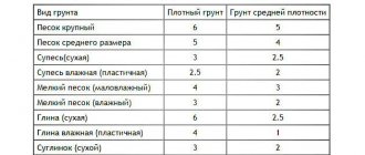
There are several methods for determining the type of land.
One of the easy ones that can be done right now is to dig four holes around the perimeter of the area, 50-60 centimeters deep, and compare them with the table in the picture. Why exactly are four holes needed around the perimeter?
The site may consist of different types of soil, and it is possible that you will have different types of soil at different ends of the territory.
Freezing table for various soil types
| Type of soil | Gap to groundwater in winter | The occurrence of a pipeline from a well or the foundation of a house |
| Rocky and semi-rocky | Any | Any, regardless of depth |
| Gravelly sands, coarse and medium | Any | Regardless of depth, but not less than 0.5 meters |
| The sands are fine and dusty | More than 2 meters below the freezing level | More than 2 meters below the freezing level |
| Sandy loam | Exceeds the calculated level of soil freezing by less than 2 meters | Not less than 3/4 of the calculated cover depth, but not less than 0.7 meters |
| Loams, clays | Less than design depth | Not less than the calculated level |
Frost heaving
Frost heaving is the deformation of the soil during freezing and thawing; it depends on the amount of water contained in the soil; the more water there is, the higher the level of heaving.
The greatest increase in volume during freezing is observed in silty and clayey soils. The volume of frozen soil increases up to 10%.
- Low volume increase in sandy soils.
- Stony and rocky soils reduce the heaving factor to zero.
- What effect does snow cover have?
- The more snow, the lower the freezing level.
- Owners of private houses damage the structure and soil by clearing the area next to the house from fallen snow. The result is uneven freezing. The ground gets the opportunity to freeze, increase in volume and damage the foundation. During the warming period, the soil will thaw unevenly and, accordingly, dry out and warm up unevenly.
Factors of influence
The level of freezing is affected by the following natural indicators:
- Vegetation on the site;
- Snow cover layer;
- Surface temperature;
- Surface type;
- Soil moisture intensity.
At zero degrees, pebble and coarse soils freeze. Fine-grained types freeze at lower temperatures, fine-grained layers consist of small veins, and accordingly, they absorb a larger amount of liquid.
Averaged data, with identical daytime temperatures, the depth is as follows:
- Loams - 130-140 centimeters;
- Clay, bulk layers 135-145 centimeters;
- Pebble soils - 172-176 centimeters;
Building regulations
Construction norms and rules (SNiP) are a set of regulations that regulate the activities of builders, architects and engineers. The information contained in these documents allows you to erect a durable and reliable building or correctly lay a pipeline.
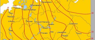
The map, with numbers of soil freezing depth marked on it, was created back in the USSR. It was contained in SNiP 2.01.01-82. But later, SNiP 01/23/99 was created to replace this regulatory act; the map was not included in it. Now it is only available on websites.
SNiP containing information about the depth of soil freezing are numbered 2.02.01-83 and 23-01-99. They list all the conditions on which the degree of frost impact on the soil depends:
Map of standard soil freezing depth in different regions of Russia
- the purpose for which the structure was erected;
- design characteristics and load on the foundation;
- depth of communications;
- location of the foundations of neighboring buildings;
- current and future topography of the development area;
- physical and mechanical soil parameters;
- features of overlays and number of layers;
- hydrogeological characteristics of the construction area;
- seasonal depth to which the ground freezes.
It has now been established that the use of SNiP 2.02.01-83 and 23-01-99 to determine the depth of soil freezing gives a more accurate result than using values taken from a map, since they take into account more conditions.
It should be noted that the calculated degree of impact of low temperatures is not equal to the actual one, since some parameters (groundwater level, snow cover level, soil moisture, sub-zero temperature parameters) are not constant and change over time.
Real ground freezing
Regional standard freezing depth
| Region | Loams, clays | The sands are fine and dusty | Sands are gravelly, medium | Pebble soils, coarse-grained |
| Moscow | 1,35 | 1,64 | 1,76 | 2,00 |
| Dmitrov | 1,38 | 1,68 | 1,80 | 2,04 |
| Vladimir | 1,44 | 1,75 | 1,88 | 2,12 |
| Tver | 1,37 | 1,67 | 1,80 | 2,03 |
| Kaluga | 1,34 | 1,64 | 1,75 | 1,98 |
| Tula | 1,34 | 1,63 | 1,74 | 1,98 |
| Ryazan | 1,41 | 1,72 | 1,84 | 2,09 |
| Yaroslavl | 1,48 | 1,80 | 1,93 | 2,19 |
| Vologda | 1,50 | 1,82 | 1,95 | 2,21 |
| Nizhny Novgorod | 1,49 | 1,81 | 1,94 | 2,20 |
| Saint Petersburg | 1,16 | 1,41 | 1,51 | 1,71 |
Soils for well construction
The construction of a new well is not a cheap undertaking; at the initial stages it is important to take into account the nuances of construction and operation that cannot be eliminated later. If the water deposits are close to the surface, any type of soil will do. If the site is located on peat or silt, the depth of liquid deposits is below ten meters and the freezing level is about two, strengthening the structure of the mine and insulating the walls of the source will be required.
The best soil cover for digging is rocky, medium and coarse sand, with a shallow freezing depth.
Breed advantage:
- The soil is not subject to heaving;
- Does not freeze;
- Does not deform;
- It washes away and does not wash away.
The rock problem is that working on this type of soil requires the time and experience of well workers.
When digging a hydraulic structure, a significant factor is the groundwater level; it must be below the freezing depth. When the liquid is higher, it will freeze, which will lead to heaving of the earth layers; this happens unevenly, which leads to deformation or partial displacement of the concrete rings.
If your participant is located on the following types of soil: silty and fine sand, loam and sandy loam, you need to determine the level of groundwater before constructing the source.
To identify such covers, use the following method: throw a fragment of earth into water, does it quickly turn into a liquid substance? - such soil will sag when wet and easily succumb to the influence of icy soil. With this type of land, it is necessary to strengthen the structure of the well.
Snow on the site also affects the depth of freezing. The more it is, the more heat underground and the higher the temperature of the earth cover.
Estimated depth of soil freezing
According to SP 22.13330.2016 Foundations of buildings and structures (updated edition of SNiP 2.02.01-83*) - the depth of soil freezing is calculated using the following formula: h=√M*k, or rather, the square root of the sum of the absolute average monthly temperatures (in winter) in a certain region. The resulting number is multiplied by k - a coefficient that has a different meaning for each type of soil:
- loams and clay – 0.23;
- sandy loam, fine and silty sand – 0.28;
- coarse, medium and gravelly sands – 0.3;
- coarse soil – 0.34.
Scheme of soil freezing under the foundation
Let's consider calculating the depth to which the soil freezes using a specific example: For the example, the city of Vologda was chosen, the average monthly temperatures for which are taken from SNiP 01/23/99 and look as follows:
| Month | Temperature in degrees Celsius | Month | Temperature in degrees Celsius |
| January | -11,6 | July | 17,2 |
| February | -10,7 | August | 15,3 |
| March | -5,4 | September | 9,4 |
| April | 2,4 | October | 3,2 |
| May | 10,0 | November | -2,9 |
| June | 15,0 | December | -7,9 |
Based on the above formula, it is necessary to add up all sub-zero temperatures. The number M is 38.5. When taking the square root it came out to 6.2. The soil in this region is loam and clay, so the coefficient is 0.23. By multiplying two numbers, the standard freezing depth of soil in Vologda is found. It is equal to 1.43 meters. If in some part of the region there are sandy soils with coarse sand, the result will be different: 6.2 * 0.3 = 1.86 m.
Correct and incorrect foundation placement relative to the level of soil freezing
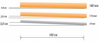
As the soil fraction becomes larger, the depth of its freezing increases. And clay soils also depend on the degree of heaving, because a large amount of moisture in the layers of the earth leads to an increase in frost heaving. The law of physics comes into play here - when water molecules freeze, they expand.
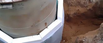
How to secure a well
To protect the well from possible problems when the soil freezes and soil heaves, the way out is to strengthen the structure of the shaft.
- Using fragmentary bracketing of concrete rings;
- Installation of metal plates along the entire height of the shaft;
- Insulation of the mine to the freezing level.
If you have water supply from a well, the pipes must be located below freezing point.
Fluctuations in soil moisture
Freezing and thawing of soil are associated with the movement of groundwater. The groundwater horizon, which is slightly elevated in autumn, decreases in winter and rises sharply when melting begins. Groundwater can come into contact with the lower surface of frozen soil and, due to its relatively high temperature (4-6°), significantly accelerate its thawing.
After a brief spring rise, the groundwater level drops and thawing slows down somewhat again.
Throughout the entire autumn-winter period, moisture moves between zones of frozen and thawed soil, always in the direction from its warm to cold layers, caused by a number of physical phenomena
Installation of brackets and anchors
To ensure stability and strength to the water source trunk, to prevent displacement of well rings and to prevent the formation of vertical breaks, staples are carried out, that is, rigid joints of reinforced concrete joints with anchors and metal staples. The structure is also fastened both during construction and at existing sources (as one of the stages of preventive and repair work).
Fixation can be done in two ways - by installing rings with a lock and staples. Locking rings are able to withstand lateral soil pressure, but do not solve the problem of vertical ruptures. Without staples, some rings may shift during soil movement, resulting in a curvature of the shaft.
How are the rings fastened?
For installation, 2-4 staples are used for each joint (the number depends on the installation location). Before installation, holes of the required size are made with a hammer drill on adjacent rings (not far from the seam), into which brackets or anchors are installed, secured with powerful bolts. As a result, the “holder” connects the top of the lower ring and the bottom of the upper one.
Features of high-quality bonding:
- It is advisable to scrape the entire shaft, regardless of the type of soil, to achieve the best stability of the structure;
- Fastening only 2-3 upper joints is not allowed if the well is located on quicksand, sandy soils, or in areas where there is heavy rainfall; in all these cases it is necessary to completely scrape the shaft;
- Fastening work is carried out using special tools, in compliance with safety rules, so you should not go down into the mine without the necessary equipment and without the skills to carry out repair work in the well.
Insulation of the mine and water pipeline
Well insulation is the process of arranging to retain heat inside the tank. For more information about mine insulation technology, also read why you need to insulate a mine.
If you can insulate a mine after the source has been used, then water supply from a well and pipes is necessary before the water supply.
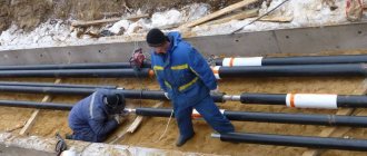
The trench is dug below the freezing level with a margin of 20-30 centimeters, and heating cable technology is used as insurance. A cable is pulled around the pipe or inside it, to which heat is supplied; this heat helps maintain a constant temperature in the plumbing system.